TL;DR: For data models, use a point cloud (LAS, LAZ), a mesh bundle ZIP, or a surface (DXF, XML) as the primary file. Orthophotos (TIF), images, and PDF reports are added as secondary files. Ground control points (CSV) and PPK files (OBS, NAV, MRK) go into a dataset with images. Orthophotos and 2D plans have their own import windows.
Formats for data models
The Create datasets window on Data models shows the type it detected next to each file.
| Format | Type shown | Role in a dataset |
|---|---|---|
| LAS, LAZ | Point cloud | Primary file. Has a unit. |
| Mesh bundle ZIP | Mesh | Primary file. Has a unit. As a secondary file it is shown in the viewer only. |
| DXF | Mesh | Primary file. Has a unit. |
| XML | Same type as DXF | Primary file. A dataset holds either a DXF or an XML, not both. |
| IFC | IFC model | Primary file for reference models. Has a unit. |
| TIF | Orthophoto | Add it to a dataset whose primary file is a point cloud or a mesh. |
| JPG and other images | Images | Add them to a point cloud or mesh dataset, or start a Photogrammetry dataset with them. |
| Report | Add it to a dataset whose primary file is a point cloud or a mesh. | |
| CSV | Ground control points | Only in a dataset with images. |
Primary and secondary files
Every primary format can also be a secondary file, for example a mesh next to a point cloud. Each dataset holds one file of each type. A second file of the same type shows This dataset already contains a file of this type. A format that is not listed shows This file type isn't supported.
Units
Point clouds, meshes, and IFC models have a unit selector next to the file: Meter, Feet, or US survey feet. Choose the unit the file was saved in.
Files for photogrammetry datasets
A dataset that starts with images has a place for each supporting file.
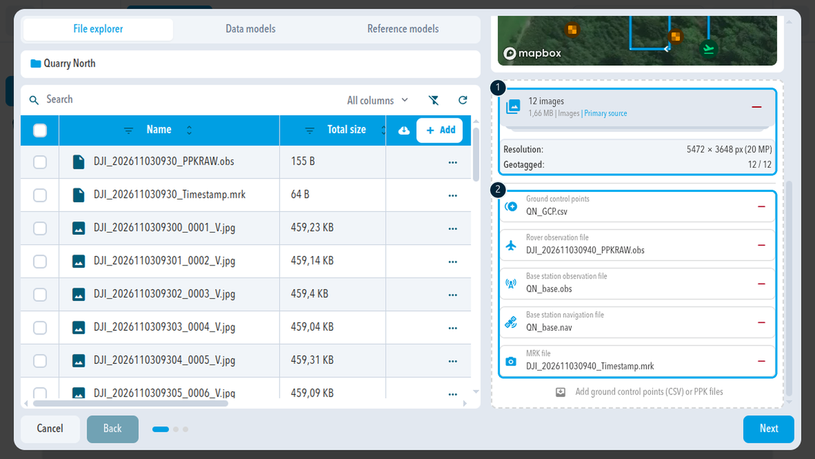
| File | Format | Description in SDX-Cloud |
|---|---|---|
| Ground control points | CSV | A CSV file with ground control points |
| Rover observation file | OBS | Observation file recorded by the drone |
| Base station observation file | OBS | Observation file of the base station |
| Base station navigation file | NAV | Navigation file of the base station |
| MRK file | MRK | Image timestamp file of the drone |
Other import windows
| Tab | Window | Accepts |
|---|---|---|
| Orthophotos | Import orthophoto | GeoTIFF files (.tif, .tiff) |
| 2D plans | Import 2D plan | DXF files |
| Reference models | Create reference model | One file from the file explorer or your computer |
Orthophotos
A standalone orthophoto goes in the Orthophotos tab. Inside a data model, an orthophoto is a secondary file, so the dataset needs a different primary file.
PocketScan and ZIP files
| Input | How it gets in |
|---|---|
| PocketScan | Direct upload from the PocketScan through the API, or a ZIP of the raw data exported from the app |
| ZIP files | SDX-Cloud identifies the content, including drone data, PPK data, and ground control points |
Coordinate system
Every file must use the coordinate system of the project.
Comments
0 comments
Please sign in to leave a comment.