The Sodex Quality Report tells you whether a drone flight is survey-grade. Check six values in the order the report shows them. One red flag means you reprocess or refly.
Before you start
- Photogrammetry processing has finished and you have the Sodex Quality Report (PDF) of that run.
- You know the GSD you planned for the flight.
- If you used ground control points (GCPs), you know how many you placed. Read Introduction to Ground Control Points for background.
Check the report
Go through the six checks. Each one names the page and the value to look at.
- On page 1, Processing Summary, find Reconstructed Images. It must show 100%, for example 299 / 299 shots. Anything lower means the flight path or conditions were not good enough, for example light, wind, blur, or low texture.
- On page 1, Processing Summary, find the Average Ground Sampling Distance (GSD). It should match the GSD you planned, because the GSD sets the accuracy you can reach: horizontal 1–2× GSD and vertical 2–3× GSD. With a GSD of 0.7 cm/px, expect roughly 0.7–1.4 cm horizontally and 1.4–2.1 cm vertically. A higher GSD than planned means the drone flew too high, the camera was not the planned one, or the altitude reference was wrong.
- On page 2, look at the colored overlap map: red is 2 images, yellow is 3, light green is 4, and green is 5 or more. Everywhere you need survey data it must be green (5+). Red, yellow, or light green patches inside your area of interest mean the flight path was not dense enough. A thin 2–4 fringe on the outer edge is normal.
- If you used GCPs, check the GCP errors on pages 3–4: the GCP RMS error (X, Y, Z, Total) and the table with one row per GCP. Every GCP error must be 1 cm or less (0.010 m). A larger error points to wrong coordinates, the wrong marker tagged, or a target that moved.
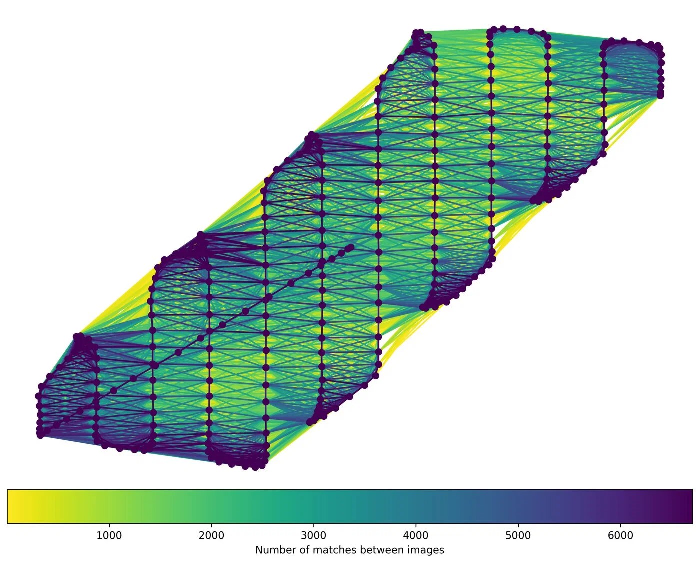
- On page 6, Tracks Details, look at the match graph. Dots are images and lines are shared features. Each pass should be tightly connected to its neighbors, with features matched across many images. Gaps between adjacent passes mean there were not enough features on the ground, or the passes were spaced too far apart. The graph below is from the guide's example flight: every pass connects to the next with many matches.
- On page 7, Sodex GCP Finder Report, find Number of images for each GCP in the Overview table. Every GCP needs at least 5 detections. A GCP with fewer barely contributes, or does not contribute at all, to the georeferencing.
Example: a GCP that was never detected
The guide's example flight has 299 shots, and checks 1 to 5 pass: all shots are reconstructed, the overlap is solid, the passes are connected, and the GCP errors are at most 0.1 cm.
Check 6 fails. GCP 3 is visible in 13 images, but the Sodex GCP Finder detected it in none (0 detections). Only 3 of the 4 GCPs were used, so the model is tied to only three points. The GCP error table lists only those 3 GCPs and looks clean, which hides the problem.
What to do next
- Reconstructed images, GSD, overlap, or tracks are a red flag: the flight path or conditions were the problem. Refly the affected area.
- A GCP error above 1 cm: check the GCP coordinates, that the right marker is tagged, and that the target did not move. Then reprocess.
- A GCP with fewer than 5 detections: tag the GCP manually, or check its coordinates and the condition of the marker, then reprocess. In the example, this is the fix for GCP 3.
Expected result
You know whether the flight is survey-grade and whether to reprocess or refly.
Comments
0 comments
Please sign in to leave a comment.